
The rapid growth of drone technology is transforming industries ranging from agriculture and construction to defense, environmental monitoring, and smart city management. Modern drones generate vast volumes of aerial video data that must be accurately interpreted by artificial intelligence (AI) systems. However, AI models can only perform effectively when trained on high-quality annotated datasets. This is where video polygon annotation plays a critical role.
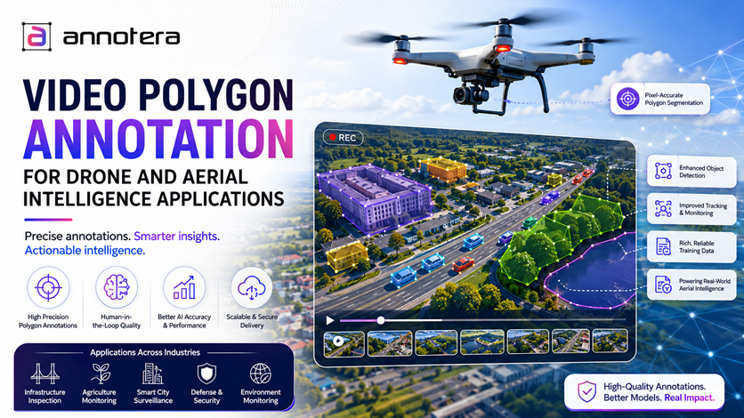
Unlike traditional bounding boxes, polygon annotation enables precise object segmentation by tracing the exact shape of an object frame by frame. For drone and aerial intelligence applications, where objects often appear small, irregular, or partially obscured, polygon annotations provide the detailed labeling necessary for reliable computer vision performance.
As a trusted data annotation company, Annotera helps organizations build accurate aerial intelligence systems through scalable video annotation services and advanced polygon labeling solutions.
Why Drone-Based Intelligence Requires Precise Annotation
Drones capture data from elevated viewpoints, creating unique challenges for AI systems. Objects such as vehicles, buildings, utility infrastructure, agricultural fields, and pedestrians often appear at varying scales and angles. Environmental factors such as shadows, weather conditions, and motion blur further complicate detection tasks.
According to the Federal Aviation Administration (FAA), the commercial drone sector continues to expand rapidly, with millions of drone operations conducted annually across various industries. Simultaneously, research from industry analysts suggests that the global drone analytics market is expected to experience significant growth throughout the decade, driven by increasing adoption of AI-powered aerial monitoring solutions.
To convert raw drone footage into actionable intelligence, AI models require accurately labeled video datasets that reflect real-world complexities.
What Is Video Polygon Annotation?
Video polygon annotation is a labeling technique in which annotators draw multi-point polygons around objects throughout video sequences. Instead of enclosing an object within a rectangular box, polygons follow the precise boundaries of the target.
For drone footage, polygon annotation is particularly valuable because aerial imagery often contains:
- Irregularly shaped structures
- Overlapping objects
- Dense urban environments
- Vegetation and terrain features
- Small moving targets
By accurately outlining object contours, polygon labels provide richer spatial information that improves segmentation, tracking, and scene understanding.
When combined with temporal video tracking, polygon annotations allow AI systems to understand how objects move and interact across consecutive frames.
Key Drone and Aerial Intelligence Applications
1. Infrastructure Inspection
Utility companies increasingly use drones to inspect power lines, pipelines, bridges, railways, and telecommunications assets.
Polygon-annotated video datasets help AI systems:
- Detect structural defects
- Identify corrosion and cracks
- Monitor vegetation encroachment
- Track maintenance issues over time
Accurate segmentation enables inspectors to focus on specific asset components rather than relying on generalized object detection.
2. Precision Agriculture
Agricultural drones collect aerial videos that help farmers monitor crop health, irrigation systems, and field conditions.
Polygon annotation allows AI models to precisely distinguish:
- Crop rows
- Weed infestations
- Disease-affected regions
- Water stress zones
- Soil variations
The result is more accurate agricultural intelligence and improved resource allocation.
3. Smart City Surveillance
Municipal authorities use drone-based monitoring systems to support urban planning and public safety initiatives.
Video polygon annotation helps AI identify and track:
- Vehicles
- Pedestrians
- Road infrastructure
- Construction zones
- Traffic patterns
These insights support traffic optimization, crowd management, and emergency response planning.
4. Defense and Security Operations
Defense organizations increasingly deploy drones for reconnaissance and surveillance missions.
In these scenarios, polygon annotations provide highly detailed object boundaries that improve:
- Target recognition
- Vehicle classification
- Perimeter monitoring
- Movement tracking
- Situational awareness
High-quality annotations are essential for reducing false detections in mission-critical environments.
5. Environmental Monitoring
Drone footage is widely used to monitor forests, coastlines, wildlife habitats, and disaster-affected regions.
Polygon-labeled datasets help AI systems identify:
- Deforestation zones
- Flood boundaries
- Wildlife populations
- Coastal erosion
- Environmental hazards
Precise segmentation improves analytical accuracy and supports informed decision-making.
Why Polygon Annotation Outperforms Bounding Boxes in Aerial Videos
Bounding boxes remain useful for many computer vision applications, but they often struggle to capture the complexity of aerial imagery.
For example, a drone may record:
- Wind turbines with intricate structures
- Roads with irregular curves
- Agricultural plots with non-uniform boundaries
- Vehicles partially hidden by trees
A bounding box includes significant background pixels that may introduce noise into the training dataset.
Polygon annotations, on the other hand, closely follow object edges, resulting in:
- Higher segmentation accuracy
- Improved object localization
- Better instance segmentation performance
- More reliable tracking results
- Enhanced model generalization
As computer vision pioneer Fei-Fei Li once noted, "The data is the food for AI." The quality and precision of annotation directly influence model performance.
Challenges in Drone Video Polygon Annotation
While polygon labeling delivers superior results, aerial video annotation presents several challenges.
Small Object Visibility
Objects captured from high altitudes may occupy only a small portion of the frame, making precise boundary creation difficult.
Rapid Motion
Fast-moving vehicles, people, or animals require consistent frame-by-frame tracking to maintain annotation quality.
Occlusion
Buildings, vegetation, and shadows frequently obscure objects in aerial footage.
Scale Variations
Drone altitude changes can significantly alter object size throughout a video sequence.
Large Data Volumes
A single drone mission can generate thousands of video frames requiring annotation.
These complexities often lead organizations to seek data annotation outsourcing solutions that provide experienced teams and scalable workflows.
The Role of Human-in-the-Loop Annotation
Although AI-assisted labeling tools can accelerate annotation, human oversight remains essential for achieving high-quality aerial datasets.
Human-in-the-loop workflows combine machine predictions with expert review, enabling:
- Faster annotation cycles
- Improved consistency
- Better quality assurance
- Reduced error rates
- Continuous model improvement
A professional video annotation company leverages these workflows to balance efficiency and accuracy while maintaining strict quality standards.
Why Organizations Choose Video Annotation Outsourcing
Building an internal aerial annotation team can be expensive and time-consuming. Many organizations therefore adopt video annotation outsourcing strategies to accelerate AI development.
Benefits include:
- Access to trained annotation specialists
- Scalable workforce capacity
- Faster project completion
- Reduced operational costs
- Consistent quality control processes
Partnering with an experienced data annotation company allows businesses to focus on model development while ensuring annotation accuracy.
How Annotera Supports Aerial Intelligence Projects
At Annotera, we provide high-precision video polygon annotation services tailored for drone and aerial intelligence applications. Our annotation experts work with advanced quality assurance frameworks to deliver reliable datasets for computer vision training.
Whether the project involves infrastructure monitoring, agricultural analytics, environmental assessment, or intelligent surveillance systems, our team delivers accurate annotations that support robust AI performance.
As a trusted video annotation company, Annotera combines domain expertise, scalable operations, and rigorous validation processes to help organizations build smarter aerial intelligence solutions.
Conclusion
Drone technology is generating unprecedented volumes of aerial video data, creating new opportunities for AI-driven intelligence. However, extracting meaningful insights from this data requires precise annotations that accurately represent complex real-world environments.
Video polygon annotation provides the detailed object segmentation necessary for advanced drone applications, enabling superior detection, tracking, and scene understanding. As industries increasingly adopt aerial intelligence solutions, the demand for high-quality annotation will continue to grow.
Organizations seeking reliable datasets can benefit from professional data annotation outsourcing and video annotation outsourcing services that deliver the accuracy required for next-generation AI systems. With expert support from Annotera, businesses can transform drone footage into actionable intelligence and unlock the full potential of aerial analytics.